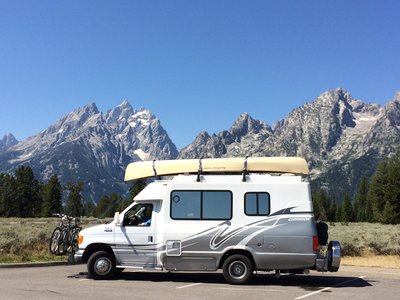

I'll be driving the Chinook from Ft. Jackson/Columbia, SC (I did basic training there in 1975 and haven't been there since), to back home in Seattle. I'll be driving cross country almost 3000 miles starting around December 27 until I get back, which may not be until next year! I'm not planning on sight seeing, just driving straight home with the mandatory stops along the way, albeit not at a fast pace. I don't want to spend more than I have to on gas with that V-10, and I have to meet my son at SeaTac airport before he drives back to college.
I've searched for cross country tips in the threads but to no avail. I got close in one thread but it morphed into talk about swingers. But I digress.
I'd like to know tips and advise for an extended trip, like this one will be. What route would be the best, where to stop, eat, gas up, sights that I should see especially if on the way. I'm not going to take many detours on this one. I've been told that taking I-10 and then diverting north somewhere is a good idea.
I would like to blog it, but I'm not high tech, so I have no idea how to do that. I'm thinking just recording myself on my iphone and uploading it to my youtube channel or Instagram or whereevr. What do you guys do?
Any other information will be greatly appreciated. I have two weeks to prepare.
Ft. Jackson/Columbia, SC to Seattle, WA
Ft. Jackson/Columbia, SC to Seattle, WA
2000 Ford E-350 415CI/6.8L V-10 Triton Superduty 4X4 Chinook Concourse XL Club Lounge

Re: Ft. Jackson/Columbia, SC to Seattle, WA
Fun times! Good things are always 2,000 miles away, right? 
What I would do is look at the NOAA graphical forecast for the CONUS a few days before you head out there, and then once you are there and ready to head back make a firm plan with the latest info. That gives you a really great "big picture" look at highs and lows, precip, "weather events" etc. for about a week. You can supplement that with 10-day forecasts for specific areas on places like Wunderground.
Your fallback will be I-10 or I-20 for warmest weather. I-40 would be great if you get a weather window. Not as far south but still not "north." If you go either I-10 or I-40 you can go over Tehachapi pass on 58 and then up I-5. Then you mostly only have to watch Siskiyou pass at the OR/Cali border. But as you get closer to the time you may be able to take another route, more direct and fewer miles. I can think of at least a dozen options but if it were me I'd wait until it is within 10-day forecast range and then start to get down to brass tacks about alternate routes.
Not that it's not fun to plan routes now, but it totally depends on the exact period when you'll be driving, given the season. This far out, you can't say (except obviously the further south the better chances, but a more northerly route might be fine in that particular time frame).
You can pretty much see where high altitude is (important out west) by looking at any overnight low on the NOAA graphical of the Continental US. Where it's cold, it's high (out west).
https://graphical.weather.gov/sectors/conus.php
Just hover your cursor over the fields on the left. "Weather" is a good one to show you any "events." You'll see at the top of that sidebar that you can move ahead in half day increments. You can zoom in or out on upper right. I find this really great for large area planning.
What I would do is look at the NOAA graphical forecast for the CONUS a few days before you head out there, and then once you are there and ready to head back make a firm plan with the latest info. That gives you a really great "big picture" look at highs and lows, precip, "weather events" etc. for about a week. You can supplement that with 10-day forecasts for specific areas on places like Wunderground.
Your fallback will be I-10 or I-20 for warmest weather. I-40 would be great if you get a weather window. Not as far south but still not "north." If you go either I-10 or I-40 you can go over Tehachapi pass on 58 and then up I-5. Then you mostly only have to watch Siskiyou pass at the OR/Cali border. But as you get closer to the time you may be able to take another route, more direct and fewer miles. I can think of at least a dozen options but if it were me I'd wait until it is within 10-day forecast range and then start to get down to brass tacks about alternate routes.
Not that it's not fun to plan routes now, but it totally depends on the exact period when you'll be driving, given the season. This far out, you can't say (except obviously the further south the better chances, but a more northerly route might be fine in that particular time frame).
You can pretty much see where high altitude is (important out west) by looking at any overnight low on the NOAA graphical of the Continental US. Where it's cold, it's high (out west).
https://graphical.weather.gov/sectors/conus.php
Just hover your cursor over the fields on the left. "Weather" is a good one to show you any "events." You'll see at the top of that sidebar that you can move ahead in half day increments. You can zoom in or out on upper right. I find this really great for large area planning.
1999 Concourse
Re: Ft. Jackson/Columbia, SC to Seattle, WA
Thanks Blue, good info. Uhhh, is this assuming that I'll be using a laptop, or can I do this with an iPhone? You scared me when you said "cursor".
I mean, I can have a laptop with me. I have heard that you can use your iphone's wifi hotspot to get online. But my laptop is Windows. gulp. Will it work with an iPhone. Maybe I should just use Kentucky windage and elevation, and a wet finger. No worries, I'll figure it out by then...I'll have to.
I mean, I can have a laptop with me. I have heard that you can use your iphone's wifi hotspot to get online. But my laptop is Windows. gulp. Will it work with an iPhone. Maybe I should just use Kentucky windage and elevation, and a wet finger. No worries, I'll figure it out by then...I'll have to.
2000 Ford E-350 415CI/6.8L V-10 Triton Superduty 4X4 Chinook Concourse XL Club Lounge
Re: Ft. Jackson/Columbia, SC to Seattle, WA
I use a laptop, but that's because I like a big screen and my brain functions better with a keyboard. But you CAN look at all of the sites I mentioned with your iPhone. I have done it. You just use your finger vs. a cursor.
When the time comes, I'd be more than happy to help you out. Oftentimes when I'm doing a "get 'er done" road trip I have a friend act as a "land agent" and do this for me. That way all I have to do is drive. You can easily "waste" hours (!) pulling over checking and re-checking weather, and sometimes on trips like this you just want to make miles. That's where the land agent can help. You drive, they use big screens and coffee time to figure stuff out I'd just be paying it forward as friends have done this for me many times. Works a treat.
When the time comes, I'd be more than happy to help you out. Oftentimes when I'm doing a "get 'er done" road trip I have a friend act as a "land agent" and do this for me. That way all I have to do is drive. You can easily "waste" hours (!) pulling over checking and re-checking weather, and sometimes on trips like this you just want to make miles. That's where the land agent can help. You drive, they use big screens and coffee time to figure stuff out
I'd just be paying it forward as friends have done this for me many times. Works a treat.1999 Concourse

Re: Ft. Jackson/Columbia, SC to Seattle, WA
No great advice but to keep up to date with the 10 day forecast on whatever route you take. Winter driving can be more stressful but prepping you rig,being prepared with an emergency kit, and topping off the gas often all should be good. Typically a more southern route this time of year works but you may hit a good window.
Just as a side note I separated from the Army (from Germany) via Ft Jackson in 1976.
Good luck with your trip and be safe. (And post a couple of pics!)
Just as a side note I separated from the Army (from Germany) via Ft Jackson in 1976.
Good luck with your trip and be safe. (And post a couple of pics!)
Steve aka SMan
2004 Premier V10
2004 Premier V10
Re: Ft. Jackson/Columbia, SC to Seattle, WA
Thanks guys.
Hooah SMan, topping off the tank is always a good idea. I don't like letting it get lower than half a tank, so yes, I will top it off when I can, especially with that V-10. I'm a leadfoot, and we do drive the "Sportscar of Motorhomes" don't we?
Blue, if we ever meet, I will top off your coffee mug with Chinook Land Agent Starbucks instant.
Hooah SMan, topping off the tank is always a good idea. I don't like letting it get lower than half a tank, so yes, I will top it off when I can, especially with that V-10. I'm a leadfoot, and we do drive the "Sportscar of Motorhomes" don't we?
Blue, if we ever meet, I will top off your coffee mug with Chinook Land Agent Starbucks instant.
2000 Ford E-350 415CI/6.8L V-10 Triton Superduty 4X4 Chinook Concourse XL Club Lounge
Re: Ft. Jackson/Columbia, SC to Seattle, WA
When I was young, I used to be able to drive cross country in about 4 or 5 days. I usually do Detroit to LA in 3 days. I would not do that again because it is not fun at all. One good thing is that I did it in the middle of summer, so I do not have to worry about weather, but right now, it can be a real pain if you drive into a snow storm. I may want to avoid Dakotas and use a more southerly route. No matter what, it will be fun in a chinook.
2000 Concourse dinette, on 1999 6.8L Ford E350 Triton V-10 Chassis
Re: Ft. Jackson/Columbia, SC to Seattle, WA
Google Maps recommends a route that goes up to Kansas City, across South Dakota and Montana. I have driven significant chunks of that, and in good weather, they are fast, easy driving. They keep the interstates clear as much as possible, and will close them if they are becoming unsafe. This time of year, the weather is a toss-up, but that's the way I'd go if I had a good forecast, because it's reasonably fast and it misses major pain points like Houston, Dallas, and Los Angeles. Plus, there's some pretty country to see along the way.
My second choice would probably be I-40 out to Las Vegas. It would add a day to the drive (at my pace and endurance), but it's more likely to be snow-free.
I-20 and I-10 are going to be longer, and hit more big cities. Dallas is a massive construction zone, Houston is just huge and busy with a lot of lanes of crazy, and Los Angeles, from what I've heard, is even worse (never been that far west).
If you do take I-10 across Texas, a few notes:
* There are long stretches in west Texas with few facilities, so start looking for a gas station when you hit a half tank.
* I-10 between San Antonio and Houston can be wall to wall people, especially if you happen to hit it on a holiday/holiday weekend (like New Years). US-90 parallels I-10 for much of that distance and is much less busy. But also fewer gas stations, so again, watch the tank.
* I'd recommend going around Houston, if possible (and not on any of the beltway/ring roads around the city - those are built up and busy). If you must go through, the best time is Sunday morning, next best will be midday on a week day.
* Watch the signs for I-10 in San Antonio - you actually have to exit to stay on I-10. GPS usually tries to route around the center of San Antonio, and some of those routes can be ... creative. It's worth having a map and making your own plan to avoid surprises.
FWIW, I've been stuck on the wrong side of New Mexico at Christmas, because they did not have the equipment to plow the interstate and keep it open. I now make sure I have a buffer of a couple of days to allow for delays, no matter the route.
My second choice would probably be I-40 out to Las Vegas. It would add a day to the drive (at my pace and endurance), but it's more likely to be snow-free.
I-20 and I-10 are going to be longer, and hit more big cities. Dallas is a massive construction zone, Houston is just huge and busy with a lot of lanes of crazy, and Los Angeles, from what I've heard, is even worse (never been that far west).
If you do take I-10 across Texas, a few notes:
* There are long stretches in west Texas with few facilities, so start looking for a gas station when you hit a half tank.
* I-10 between San Antonio and Houston can be wall to wall people, especially if you happen to hit it on a holiday/holiday weekend (like New Years). US-90 parallels I-10 for much of that distance and is much less busy. But also fewer gas stations, so again, watch the tank.
* I'd recommend going around Houston, if possible (and not on any of the beltway/ring roads around the city - those are built up and busy). If you must go through, the best time is Sunday morning, next best will be midday on a week day.
* Watch the signs for I-10 in San Antonio - you actually have to exit to stay on I-10. GPS usually tries to route around the center of San Antonio, and some of those routes can be ... creative. It's worth having a map and making your own plan to avoid surprises.
FWIW, I've been stuck on the wrong side of New Mexico at Christmas, because they did not have the equipment to plow the interstate and keep it open. I now make sure I have a buffer of a couple of days to allow for delays, no matter the route.
1999 Premier, now minus all passenger side cabinets and appliances 
Re: Ft. Jackson/Columbia, SC to Seattle, WA
Yeah, so much depends on the weather at that exact time. Luckily, 10-day forecasts are really good now. Oh maybe not for sure about whether it might rain on your picnic; but for big winter storm trends it's not like one is going to sneak in that you can't read about way ahead of time. Especially going east to west (since the weather is going to basically move west to east, you/they can "see it coming" from a long way away.
Some of the northerly routes might be fine at that time. But you'd want a good long window cause who wants to get stuck in Wyoming in January? And man, the blowing and drifting there - a couple of inches of snow can really feel like a lot. I grew up in snow country and it really is all about the specific day's weather. One day you are white-knuckling it through a blizzard, fearing for your life (but maybe you have to get to work); the next day it's sunny and the roads are dry.
I'd be hoping for I-40 (watching ABQ and Flag), still check more northerly routes (but not planning on them), and save I-10 or I-20 for fallbacks. I'm going to have to look at my map again, because I did a cross country a couple of years ago on I-10 in January, and I don't remember hitting very many cities. Maybe after the Texas plains I didn't mind? At any rate, I wasn't going any other route since my destination was right off I-10 that time. Good point about those long stretches in Texas. There is no problem as long as you don't accidentally plan to get gas right in the middle of one. You also have to watch the wind a bit (I brought my Chinook west from Dallas in January, natch).
BTW you'll have close to 400 miles range on gas (obvs depending on speed and wind). I'm usually looking starting at about 300 unless I'm crossing the mohave (or Texas). I'm the opposite in that as long as I know there is gas up ahead I stop as few times as possible. Not that I go down to fumes, but I wait until maybe 1/4-1/8 tank. I find that if there is going to be a fender bender, my card's going to get skimmed, etc. -- it's going to be at a gas station (the former more likely if I'm towing, and trying to cram into those tiny gas aisles where parts of the rig or car stick out). Of course if it were twenty below or I were out in the boonies I'd do differently because at that point gas is a bigger safety factor. Anyway, that's just me. Before my next trip I'm going to program my Scangauge for the gas tank percent. That should be amusing (made note about it in Scangauge thread).
Funny thing is, that cross-country trip I mentioned? Got there and back in just over four days. It was a utility trip all the way. And I didn't push it that hard because I could have taken longer if I'd wanted to. I just was in the groove, and had good weather and a good "land agent" -- so all I had to do was drive. But I was driving my car. Not much else to do but drive. And it's easy to do the speed limit without much gas penalty. Driving the Chinook I (ironically) find it harder to make time. Because it's so tempting to stop! Hey, there is my living room back there. I could make a snack. Read on the couch! So relaxing. It's impossible to make time And if you get sleepy or bored: Again that living room is RIGHT THERE. You could pull over... Good luck making miles 
If I were you I'd be the same: I'd want to plan RIGHT NOW. So exciting! But hey, the 10-day will start to be relevant in in six days!
Some of the northerly routes might be fine at that time. But you'd want a good long window cause who wants to get stuck in Wyoming in January? And man, the blowing and drifting there - a couple of inches of snow can really feel like a lot. I grew up in snow country and it really is all about the specific day's weather. One day you are white-knuckling it through a blizzard, fearing for your life (but maybe you have to get to work); the next day it's sunny and the roads are dry.
I'd be hoping for I-40 (watching ABQ and Flag), still check more northerly routes (but not planning on them), and save I-10 or I-20 for fallbacks. I'm going to have to look at my map again, because I did a cross country a couple of years ago on I-10 in January, and I don't remember hitting very many cities. Maybe after the Texas plains I didn't mind? At any rate, I wasn't going any other route since my destination was right off I-10 that time. Good point about those long stretches in Texas. There is no problem as long as you don't accidentally plan to get gas right in the middle of one. You also have to watch the wind a bit (I brought my Chinook west from Dallas in January, natch).
BTW you'll have close to 400 miles range on gas (obvs depending on speed and wind). I'm usually looking starting at about 300 unless I'm crossing the mohave (or Texas). I'm the opposite in that as long as I know there is gas up ahead I stop as few times as possible. Not that I go down to fumes, but I wait until maybe 1/4-1/8 tank. I find that if there is going to be a fender bender, my card's going to get skimmed, etc. -- it's going to be at a gas station (the former more likely if I'm towing, and trying to cram into those tiny gas aisles where parts of the rig or car stick out). Of course if it were twenty below or I were out in the boonies I'd do differently because at that point gas is a bigger safety factor. Anyway, that's just me. Before my next trip I'm going to program my Scangauge for the gas tank percent. That should be amusing
(made note about it in Scangauge thread).Funny thing is, that cross-country trip I mentioned? Got there and back in just over four days. It was a utility trip all the way. And I didn't push it that hard because I could have taken longer if I'd wanted to. I just was in the groove, and had good weather and a good "land agent" -- so all I had to do was drive. But I was driving my car. Not much else to do but drive. And it's easy to do the speed limit without much gas penalty. Driving the Chinook I (ironically) find it harder to make time. Because it's so tempting to stop! Hey, there is my living room back there. I could make a snack. Read on the couch! So relaxing. It's impossible to make time
And if you get sleepy or bored: Again that living room is RIGHT THERE. You could pull over... Good luck making miles If I were you I'd be the same: I'd want to plan RIGHT NOW. So exciting! But hey, the 10-day will start to be relevant in in six days!
1999 Concourse
Re: Ft. Jackson/Columbia, SC to Seattle, WA
Since you are not doing sight seeing, I would take the most pleasant route for drivers. If it is in the summer, I will definitely go with the I-90 and stop by Yellowstone and spend a week there. But if you want relatively good route, I would not mind using I-40 to Vegas then head north and spend an extra day on the road. If you want to save fuel, however, I would not do the I-40 detour unless the weather is bad up north. There are so many choices, and it really up to your preference. I hate to drive across I-40 near Amarillo, TX. Got hit with wind storms twice, and it was so strong that it pulled my windshield wipers out from the glass so that it was just wiping in mid-air. Glad that it was very localized event, however.
2000 Concourse dinette, on 1999 6.8L Ford E350 Triton V-10 Chassis